The SustainableMobility NI Map
We have created a map of how NI’s public transport network could look if the solid (funded and unfunded) proposals we are calling for are implemented. Click on the map to show a full-browser/download a hi-res version. The map source is open source (Creative Commons license) and can be found on GitHub.

This map assumes the following proposals/projects are implemented/finished:
- The All Island Strategic Rail Review, but assumes for simplicity, that any capacity improvements between Belfast and Lisburn follow the existing route.
- The Condor Ferries shuttle service between Titanic Quarter and Bangor Marina.
- The Circle Line upgrades around Belfast/Antrim/Lisburn.
- The Narrowwater bridge.
- The proposed Glider Extensions to Carryduff and Glengormley.
Furthermore, a bunch of easy-to-achieve shuttle services and interchanges are provided:
- The northbound Glider extension is extended further to a rail interchange at Mossley West.
- Yorkgate station is connected to the ferry terminals for Liverpool, Cairnryan and the Isle of Man. It’s not shown yet, but with a footbridge between Titanic Quarter and the other side of Belfast Lough, this could become a mega rail/Glider-interchange for all ferries, especially if the footbridge was provided with lights, a roof and open sides to be usable at all times.
- The new Narrowwater bridge is used to provide Newcastle to Dundalk bus services.
- The Lough Foyle ferry becomes connected with a bus or buses to provide a link from the Donegal Northern Headlands to the Derry-Londonderry coastal railway line at Bellarina.
- In general, bus/train interchanges in a single town/city are considered seamless, even though this is not the case in some places.
Not included are tourist/heritage railways, in particular the Downpatrick & County Down Railway and the Giant’s Causeway & Bushmills Railway.
Intermediate bus and glider stations are not shown, but all rail stations are. Whether new stations (e.g. Belfast Int’l Airport and Limavady) are added using spurs off a line or by redirecting a line/redirecting services is ignored for simplicity.
Translink Maps
We’re not aware of any map from Translink showing all services, but there is one that comes pretty close, featured as part of a series of nice maps from Moovit that look official but don’t seem to be kept up to date. In particular the first map that combines longer-distance rail and coach (Goldline) services gives a good idea of what we have now (compared to what we could have, above) using a similar base of places and corridors:

Translink have a number of mode-specific maps, shown below.
NI Railways
Glider

Metro (Belfast)

Finally, here’s a hard to find (and for us, hard to understand) map covering iLink fare zones. These are explained on our Travel Advice page. The whole scheme is centred on Belfast with a bit of a fudge to try and make it usable for Derry-Londonderry and the North West too.
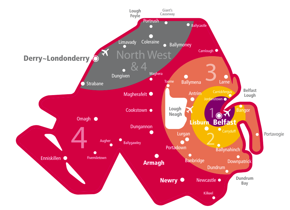
(Map taken from this PDF, which may not be up to date, but we assume the zones have not changed)